Radar Mapping Techniques and Applications

Paula Messina
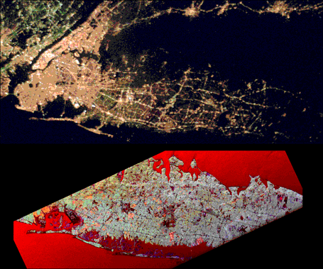
New York City, Long Island and Vicinity (as imaged
during NASA's SIR-C SL1 Mission, April 1994)
At the top is a visible-light photograph of the
area, taken by Shuttle astronauts at 3:00am on April 20, 1994. The bottom image is a radar view of the same
area taken at 3:00am on April 16, 1994.
Notice how the radar image shows a great amount of surface detail, despite night acquisition. Note, for
example: the relief of the terminal moraine on Long Island's North Shore; the surface waves on the Atlantic
Ocean; and the flat network of highways around the City.
 What is radar?
SLAR (Side-looking airborne radar) Systems Operations
Real Aperture, versus Synthetic Aperture Radar (SAR) Operations
Transmission and Return Characteristics of Radar Signals
"Fancy" Radar Techniques (Interferometry and Multipolarization)
A Review of Radar Imaging Instruments and Projects
 Bibliography
 Return
to Hunter's Terrain Analysis Home Page
Return
to Hunter's Terrain Analysis Home Page
URL http://everest.hunter.cuny.edu/terrain/radar1.html
Last update: June 20, 1996
by Paula Messina
Your comments, suggestions and questions are welcome!
pmessina@everest.hunter.cuny.edu