![]()
Some representative SAR systems include:
![]() AN/APQ-102: An early radar system that used a single horizontally polarized X-band (3 cm.)
For transmission and reception. This instrument imaged large areas of the United States with 10 meter
resolution (both range and azimuth).
AN/APQ-102: An early radar system that used a single horizontally polarized X-band (3 cm.)
For transmission and reception. This instrument imaged large areas of the United States with 10 meter
resolution (both range and azimuth).
![]() Goodyear Electronic Mapping System: This sensor was similar to the AN/APQ-102, and was
used for "Earth resource surveys." Resolution was about the same as for the original instrument.
Goodyear Electronic Mapping System: This sensor was similar to the AN/APQ-102, and was
used for "Earth resource surveys." Resolution was about the same as for the original instrument.
![]() JPL L-Band Radar: NASA's Jet Propulsion Lab
developed this instrument for resource survey
missions, concentrating on the Arctic and sub-Arctic regions. The multipolarization capabilities allowed for
HH, HV, VV and VH images with a resolution of about 20 meters.
JPL L-Band Radar: NASA's Jet Propulsion Lab
developed this instrument for resource survey
missions, concentrating on the Arctic and sub-Arctic regions. The multipolarization capabilities allowed for
HH, HV, VV and VH images with a resolution of about 20 meters.
![]() ERIM/CCRS Multispectral Radar System: Spectral
reflectance characteristics of Earth surfaces
were studied with this airborne instrument. With both mulitpolarization and multispectral (two X-bands, two
L-bands and two C-bands) capabilities, the resulting images contained more information than those produced
by earlier SARs. The CCRS's resolution is in the order of 10 meters.
ERIM/CCRS Multispectral Radar System: Spectral
reflectance characteristics of Earth surfaces
were studied with this airborne instrument. With both mulitpolarization and multispectral (two X-bands, two
L-bands and two C-bands) capabilities, the resulting images contained more information than those produced
by earlier SARs. The CCRS's resolution is in the order of 10 meters.
![]() Apollo Lunar Sounder
System: The first multispectral SAR used in space was this instrument,
launched aboard Apollo 17. Since its primary purpose was for subsurface sounding, the depression angle was
too steep for lunar terrain modeling.
Apollo Lunar Sounder
System: The first multispectral SAR used in space was this instrument,
launched aboard Apollo 17. Since its primary purpose was for subsurface sounding, the depression angle was
too steep for lunar terrain modeling.
![]() Seasat: Seasat was an orbital
radar system that was launched in June, 1978. Although Seasat was operational for only 106 days, it returned
a wealth of oceanographic data, with a fully-focused resolution of 6.25 meters x 25 meters.
Seasat: Seasat was an orbital
radar system that was launched in June, 1978. Although Seasat was operational for only 106 days, it returned
a wealth of oceanographic data, with a fully-focused resolution of 6.25 meters x 25 meters.
Among Seasat's suite of instruments were: an SAR (which imaged sea and land surfaces); a radar scatterometer (which measured near-surface wind speed and direction); a radar altimeter (measuring "sea levels" and wave heights to great precision); and a scanning multi-channel microwave radiometer (measuring surface temperature, wind speeds and sea ice cover). Information received from Seasat has served as a baseline for all subsequent and future oceanographic and climate studies. The instrument itself was the prototype for other ventures, including the Magellan Mission's SAR, and the space shuttle's SIR-A, SIR-B and SIR-C. Another Seasat-like sensor was aboard the Mars Explorer which was "lost" in 1993.
A short circuit drained all power from Seasat's batteries in October 1978.
Click here to see a Seasat image of Death Valley (.GIF format).
![]() TOPEX/Poseidon: Designed and constructed
jointly by the French space agency and NASA,
this instrument uses a radar scatterometer to evaluate world ocean circulation, and radar altimetry to
determine the topography of the sea. The accuracy of the altimetry measurements are estimated to be to
within 3 centimeters. Using three independent tracking systems (GPS, a twelve-station ground-based laser
network, and DORIS), the exact location of TOPEX/Poseidon is known to within 2 centimeters. Because
of its unprecedented precision, large oceanographic phenomena such as El Nińo may be studied in great
detail.
TOPEX/Poseidon: Designed and constructed
jointly by the French space agency and NASA,
this instrument uses a radar scatterometer to evaluate world ocean circulation, and radar altimetry to
determine the topography of the sea. The accuracy of the altimetry measurements are estimated to be to
within 3 centimeters. Using three independent tracking systems (GPS, a twelve-station ground-based laser
network, and DORIS), the exact location of TOPEX/Poseidon is known to within 2 centimeters. Because
of its unprecedented precision, large oceanographic phenomena such as El Nińo may be studied in great
detail.
![]() SIR-A and SIR-B: Based on Seasat's SAR, the Shuttle
Imaging Radar (SIR) was developed and flown in 1981 (SIR-A) and 1984 (SIR-B). SIR-A used a fixed look
angle of 50°, while SIR-B's antenna could be mechanically tilted.
SIR-A and SIR-B: Based on Seasat's SAR, the Shuttle
Imaging Radar (SIR) was developed and flown in 1981 (SIR-A) and 1984 (SIR-B). SIR-A used a fixed look
angle of 50°, while SIR-B's antenna could be mechanically tilted.
Each instrument made its share of heretofore unknown archaeological and natural features. For example, SIR-A penetrated cloud-covered rain forests in Guatemala to disclose agricultural canals dug by the Maya; SIR-B uncovered buried riverbeds under wind-blown sand in Egypt. [L-Band is particularly useful when ground penetration of signal is desired, and it is with this frequency that subsurface studies generated paleomaps of the ancestral Nile.]
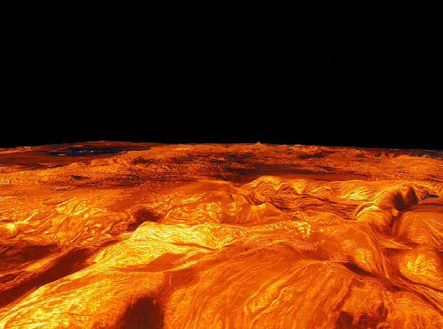
![]() Magellan Imaging Radar: The
Magellan Spacecraft was launched aboard the shuttle Atlantis in
May 4, 1989. Arriving at Venus on August 10, 1990, its synthetic aperture radar sent back detailed terrain
data until 98% percent of the planet was mapped. On October 12, 1994, the spacecraft was lowered into the
Venusian atmosphere, where it probably vaporized.
Magellan Imaging Radar: The
Magellan Spacecraft was launched aboard the shuttle Atlantis in
May 4, 1989. Arriving at Venus on August 10, 1990, its synthetic aperture radar sent back detailed terrain
data until 98% percent of the planet was mapped. On October 12, 1994, the spacecraft was lowered into the
Venusian atmosphere, where it probably vaporized.
Magellan orbited Venus in eight-month cycles, each time using a slightly different look angle. As a result, three-dimensional models of the terrain were produced and animated at JPL. Highly detailed altimetry data were returned as well, allowing actual elevations of surface features to be known. Click here to see a 3-D perspective of Venus' Ovda Regio region (154 K). Click here to see an animation of Magellan's view of Venus (303K) in MPEG format.
![]() AIRSAR/TOPSAR: These two airborne
multifrequency, multipolarization SARs are flown aboard specially-adapted DC-8 aircraft. AIRSAR, using
P-band (68 cm.), L-band (24 cm.) and C-band (5.6 cm.) energy, can adjust its incidence angle from 0° to
70°. It achieves a spatial resolution of approximately 12 m. x 12 m.
TOPSAR (Topographic Synthetic Aperture
Radar), an interferometric radar mapper, is about three
times more accurate than any previously developed topographic mapper. Radar interferometry measures the
difference from each of the two antennas to a point on the ground to determine the height of that point by
triangulation. The separation of the antennas, which forms the third side of the triangle, is called the baseline.
Although several modifications were made, TOPSAR uses some of the same hardware as AIRSAR.
TOPSAR adds a pair of C-band antennas to the DC-8 fuselage that are displaced vertically to form an
interferometer. Spatial resolution of this instrument approaches 10 meters x 10 meters, with a vertical
accuracy of as little as 1 meter in non-mountainous areas (accuracy is diminished on mountainous terrains).
AIRSAR/TOPSAR: These two airborne
multifrequency, multipolarization SARs are flown aboard specially-adapted DC-8 aircraft. AIRSAR, using
P-band (68 cm.), L-band (24 cm.) and C-band (5.6 cm.) energy, can adjust its incidence angle from 0° to
70°. It achieves a spatial resolution of approximately 12 m. x 12 m.
TOPSAR (Topographic Synthetic Aperture
Radar), an interferometric radar mapper, is about three
times more accurate than any previously developed topographic mapper. Radar interferometry measures the
difference from each of the two antennas to a point on the ground to determine the height of that point by
triangulation. The separation of the antennas, which forms the third side of the triangle, is called the baseline.
Although several modifications were made, TOPSAR uses some of the same hardware as AIRSAR.
TOPSAR adds a pair of C-band antennas to the DC-8 fuselage that are displaced vertically to form an
interferometer. Spatial resolution of this instrument approaches 10 meters x 10 meters, with a vertical
accuracy of as little as 1 meter in non-mountainous areas (accuracy is diminished on mountainous terrains).
![]() SIR-C/X-SAR: This suite of radar instruments
is a joint venture of NASA, the German Space Agency (DARA) and the Italian Space Agency (ASI). Flown
on two shuttle missions, STS-59 (April 1994) and STS-68 (October 1994), these sensors have yielded a total
of 107 terabits of terrain data, corresponding to 149 million square kilometers (58 million square miles) of
coverage (about 14% of the Earth's surface).
SIR-C/X-SAR: This suite of radar instruments
is a joint venture of NASA, the German Space Agency (DARA) and the Italian Space Agency (ASI). Flown
on two shuttle missions, STS-59 (April 1994) and STS-68 (October 1994), these sensors have yielded a total
of 107 terabits of terrain data, corresponding to 149 million square kilometers (58 million square miles) of
coverage (about 14% of the Earth's surface).
The information obtained would fill 45,000 encyclopedia volumes. When all radars are operating, they produce 225 million bits of data per second, or the equivalent of 45 simultaneously operating television stations. (All analogies are courtesy of NASA's JPL SIR-C Fact Sheet.)
SIR-C is a two-band synthetic aperture radar, using L-Band (23 cm.) and C-Band (6 cm.), with multipolarization capabilities. The SIR-C antenna is the most massive piece of hardware ever assembled at JPL (10,500 kilograms); its dimensions are 12 meters by 4 meters. Unlike SIR-A and SIR-B, the radar transmitters in SIR-C are embedded in the antenna, and may be adjusted to result in 15° to 55° angles of incidence.
X-SAR was built jointly by DARA and ASI; it is a single band (X-band, 3 cm.) single polarization (VV) radar. X-SAR could be used in conjunction with SIR-C, or as a "stand alone" instrument.
By flying the radar observatory on two shuttle flights during different seasons, comparisons of surface and environmental features (i.e., lava flows, faults, vegetation cover, etc.) were made.
 Click on the JPL logo to connect to their home page of images of both SIR-C/X-SAR missions.
Among other notable radar sensors are the former Soviet Union's Cosmos-1870 (operational from 1987 until 1989, and a prototype for its later ALMAZ-1 system), ESA's ERS-1 (launched in 1991) and ERS-2, Japan's JERS-1 (launched in 1992), and the Canadian-United States project Radarsat, which was launched in November, 1995.
![]() Return to the Radar Mapping Home Page
Return to the Radar Mapping Home Page
![]() Return to Hunter's Terrain Analysis Home Page
Return to Hunter's Terrain Analysis Home Page