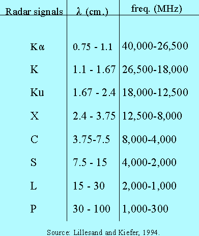

Radar, which is an acronym for radio detection and ranging, refers to a portion of the electromagnetic spectrum with wavelengths extending from 1 mm. to 1 m. The term microwave, although sometimes used interchangeably with the term radar, is therefore a misnomer since these waves are about 2.5 million times longer than the shortest visible light waves!
Advantages of utilizing these wavelengths include their ability to penetrate haze, light rain, clouds and other atmospheric particulates. Radar views of Earth may be obtained at any time of day (even at night), under most any condition. The images are often very different from those taken in other wavelengths, and hence reveal supplementary information about terrain surfaces. Since microwaves are much longer than visible light waves, radar images often appear "smoother" than visible spectrum images.
Radar sensors may be divided into two groups: passive and active. Passive systems simply record microwave-region wavelengths of energy emitted from the Earth's surface. Microwave radiometers are passive systems. The signal they receive is an amalgam of thermal emissions from the ground and the atmosphere, plus scattered emissions originating in the atmosphere and extraterrestrially. Active systems record the reflected signals of microwaves they transmit. This Internet site will concentrate on active radar systems.
There are three types of active radar remote sensors. They include:
![]()
![]() Click here to connect to a great
glossary of meteorological radar terms!
Click here to connect to a great
glossary of meteorological radar terms!
![]() Click here to see the current meteorological radar summary image of the United States.
Click here to see the current meteorological radar summary image of the United States.
![]() Return to the Radar Mapping Home Page
Return to the Radar Mapping Home Page
![]() Return to Hunter's Terrain Analysis Home Page
Return to Hunter's Terrain Analysis Home Page