![]()
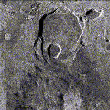
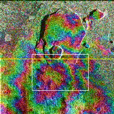
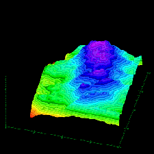
The first image (left) is an X-band image, taken on October 4, 1994 during the second radar mapping mission of SIR-C/X-SAR. The second image (middle) is a composite of the 10/4/94 X-band image, and another one captured on April 13, 1994. The two data sets were used to generate "interferometric fringes." The yellow rectangular frame in the center image shows the extent of the topographic model generated by the interferometric technique (right).
SIR-C/X-SAR utilized the relatively new technology of interferometry. On successive passes of a nearly fixed orbit, two images of the same geographic area were generated, producing two long swaths of interferometric data. This procedure was accomplished at dozens of sites around the world. Digital elevation computer models were created at all three radar frequencies to produce the 3-D effect. This demonstration was carried out in preparation for TOPSAT, a mission planned for later this decade to measure global topography and centimeter-scale topographic change using laser and radar interferometry. The focus of these experiments is to improve our assessments of events such as flooding, subsidence, mudflows, glaciation and volcanic eruptions.
![]()
A single band SLAR may maximize the information gathered if it transmits and receives polarized signals. Most early mulitpolarization radars transmitted signals with horizontal (H) polarization. Different terrain surfaces depolarize the reflected signal to varying degrees so that when received there are horizontal (H) components and vertical (V) components. Modern instruments can emit either vertically- (V) or horizontally- (H) polarized signals, and can receive both components as well. Other sensors can emit and receive circular polarized microwaves, which send and detect the pulses in an ever-rotating plane.
Images recorded with polarized microwaves are classified as: HH (if horizontally-polarized waves are transmitted and received); HV (if the emitted signal is horizontally polarized, but only the vertical polarization component of the return signal is measured); VV (vertical transmission/vertical reception) or VH (vertical transmission/horizontal reception). Even using only one band, each of the four resulting images will offer a unique view. Multipolarization is particularly useful for vegetation studies, since the data will allow the investigator to observe different types of crops, and to "see" the volume and distribution of trees under forest canopies.
![]() Return to the Radar Mapping Home Page
Return to the Radar Mapping Home Page
![]() Return to Hunter's Terrain Analysis Home Page
Return to Hunter's Terrain Analysis Home Page