![]()
Relief, a vertical measurement, may be portrayed on a two-dimensional map in several ways. Terrain analysis involves the symbolization and representation of a landscape. Familiar topographic products include:
Maps depicting topography have been produced throughout cartographic history, but it is only recently that point elevations have been collected in precise digital form.
![]()
At the heart of terrain analysis is the raw elevation data, which may have been collected in a variety of ways. In the past all topographic data was collected by surveyors using instruments such as the level, transit and theodolite (click here for further links to land surveying information from the Huntinton Technology Group.). Today, the same data may be collected by survey teams, but now using GPS (Global Positioning System) receivers.
There are currently many excellent reference sources on GPS applications on the Internet. Some great "jumping-off" spots include:
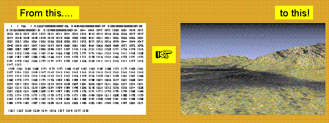
Terrain information is currently acquired by remote sensors on airborne or spaceborne platforms, and is usually stored as a Digital Elevation Model (DEM). A DEM is a file of rows (x) and columns (y) corresponding to pixel locations. The value assigned to each pixel is the z value, or elevation. Many DEMs are available free of charge, and are downloadable from the USGS.
However, an ASCII file of z values is virtually meaningless without the ability to "visualize" the landscape. Image processing software makes it possible to "view" the "virtual" landscape in a variety of ways.
For example...
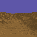
![]() Using
DEMs a series of virtual terrains can be generated and animated, as below.
Using
DEMs a series of virtual terrains can be generated and animated, as below.
Click on the image above to see Paula Messina's Stovepipe Wells to Racetrack
Playa (Death Valley) Fly-Through. (MPEG format)
Click here to connect to San Diego State's Death Valley Fly-Through Home Page (Quicktime and VRML formats)
![]() Click here for an excellent introduction entitled "Relief: Depicting
a Surface on a Map" by R.J. Phillips.
Click here for an excellent introduction entitled "Relief: Depicting
a Surface on a Map" by R.J. Phillips.
![]() Return to Hunter's Terrain Analysis Home Page
Return to Hunter's Terrain Analysis Home Page