Cylindrical Projections
I. What is a cylindrical projection?
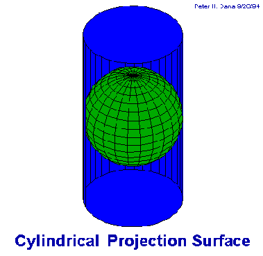
A cylindrical projection can be imagined in its simplest form as a
cylinder that has been wrapped around a
globe at the equator. If the graticule of latitude and longitude are projected
onto the cylinder and the cylinder unwrapped, then a grid-like pattern
of straight lines of latitude and longitude would result. The meridians
of longitude would be equally spaced and the parallels of latitude would
remain parallel but may not appear equally spaced anymore. In reality cylindrical
map projections are not so simply constructed.
The three aspects of the cylindrical projections:
- Tangent or secant to equator is termed regular,
or normal.
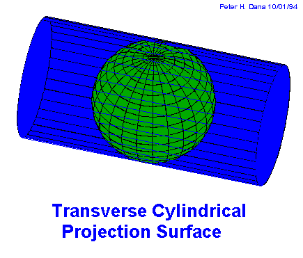
- Tangent or secant to a meridian is the transverse
aspect.
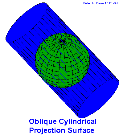
- Tangent or secant to another point on the globe is called oblique.
Sources
Text: Originally prepared for the Seminar in Map Projections
and is currently being adjusted to a common format with the other Map Projection
Pages.
Graphics: Come from two sources: 1. Paul S. Anderson, these
are graphics containing the graticule shorelines and 2. Shaded maps by
Peter H. Dana, The Geographers Craft Project. Department of Geography,
The University of Texas at Austin. http://www.utexas.edu/depts/grg/gcraft/notes
/mapproj/mapproj.html
II. Regular cylindrical projections
Characteristics
- Lines of latitude and longitude are parallel intersecting at 90 degrees.
- Meridians are equidistant.
- Forms a rectangular map.
- Scale along the equator or standard parallels is true.
- Simple construction.
- Can have the properites of equidistance, conformality or equal area.
Equirectangular Projection
- Among the oldest projections and simplest.
- Parallels are equally spaced.
- Plate Carree-square grid.
- History
- Invented by Marinus of Tyre at about 100 A.D.
- Popular during Renaissance.
- Declined in popularity in 18th century.
- Used for regional maps.
- Conformal.
- Meridians unequally spaced, distance increases away from equator directly
proportional to increasing scale.
- Loxodromes or rhumb lines are straight.
- Used for navigation and regions near equator.
- History
- Invented in 1569 by Gerardus Mercator (Flanders) graphically.
- Standard for maritime mapping in the 17th and 18th centuries.
- Used for mapping the world/oceans/equatorial regions in 19th century.
- Used for mapping the world/U.S. Coastal and Geodetic Survey/other planets
in 20th century.
- Much criticism recently.
Lambert's Cylindrical Equal Area
- Meridians are equally spaced
- Parallels get closer near poles.
- Parallels are sines.
- True scale at equator.
- History
- Invented in 1772 by Johann Heinrich Lambert with along with 6 other
projections.
- Prototype for Behrmann and other modified cylindrical equal-area projections.
- Neither equal area or conformal.
- Projected geometrically from a point on the equator opposite meridian
being projected
- History
- Invented by James Gall in 1855
- Modified in 20th century by changing standard parallels
- America's compromise projection
- 4 proposals with different lat. spacing
- Perspective compromise
- Modified Mercator A
- Modified Mercator B-.8 spacing of Mercator
- Modified Gall's
- History
- Invented by Osborn Maitland Miller (Scot) in 1942
- Hired by U.S. Dept. of State
III. Transverse Cylindrical Projections
Cassini Projection
- Equirectangular rotated 90 degrees-applied to ellipsoid
- Scale true along central meridian, meridians 90 degrees to central
meridian, and equator
- History
- Invented by Giovanni Cassini
- Used for topo maps in France until 1803
- Modified in 1810 by Soldner and used for topo maps in U.K. and German
States
- Declined use in 20th century
Transverse Mercator
- Mercator rotated 90 degrees
- Applied to sphere
- Conformal
- History
- Invented by Lambert in 1772
- Modified for ellipse by Gauss in 1822, Kruger in 1912
- Used for regions with a N/S expanse
- Used for topo mapping
- Basis for State Plane Coordinate System, UTM
Transverse Cylindrical Equal Area Projection
- Transverse of Lambert's Cylindrical Equal Area-for N/S expanse
- Used sparingly
Modified Transverse Mercator
- 2 standard meridians-Guozco Li (1981)
IV. Oblique Cylindrical Projections
Oblique Mercator
- 45 degree tilt of regular cylinder
- Introduced by Charles Peirce in 1894 with little fan fare
- Used by Debes's Atlas for S.E. Asia and Central America
Return to the Map Projection Home Page
Last modified 5/9/97 by Karen Mulcahy kam@everest.hunter.cuny.edu