Student's or Personal Globes
The following globes can be constructed for personal
use. In some cases they are free on-line and in others, they can be ordered
via information provided at the linked sites.
 The
RealEarth GlobeMap is
a 14-faceted teaching tool. There are two current editions of the GlobeMap
a 12" diameter model and a 5" diameter model. The RealEarth web
site contains ordering information, and extensive teachers resources. The
GlobeMaps can be ordered by individuals and schools and there are also
line map globes on the web site that may be downloaded, printed, and pasted
together for non-commercial use.
The
RealEarth GlobeMap is
a 14-faceted teaching tool. There are two current editions of the GlobeMap
a 12" diameter model and a 5" diameter model. The RealEarth web
site contains ordering information, and extensive teachers resources. The
GlobeMaps can be ordered by individuals and schools and there are also
line map globes on the web site that may be downloaded, printed, and pasted
together for non-commercial use.
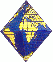 The
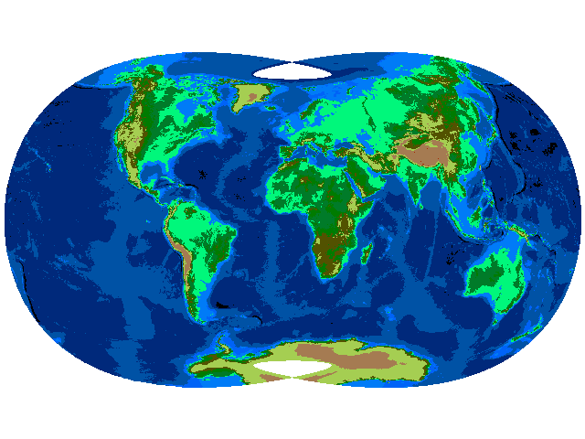
Modified Collignon, or Clarke's Butterfly This map projection is referred
to as the Butterfly as a result of its shape when flattened. Its completed
form is composed of eight triangular sides, comprising an octahedron. The
projection used for each face is a modified Collignon. Download the postscript
version for better output.
The
Modified Collignon, or Clarke's Butterfly This map projection is referred
to as the Butterfly as a result of its shape when flattened. Its completed
form is composed of eight triangular sides, comprising an octahedron. The
projection used for each face is a modified Collignon. Download the postscript
version for better output.
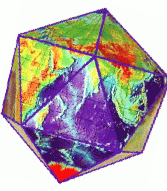 Check
out the Surface of the Earth
Icosohedron Globe at the National Geographic Data Center at NOAA There
is an initial $5 charge but each globe is only $0.50.
Check
out the Surface of the Earth
Icosohedron Globe at the National Geographic Data Center at NOAA There
is an initial $5 charge but each globe is only $0.50.
Map Projection Related Amusements

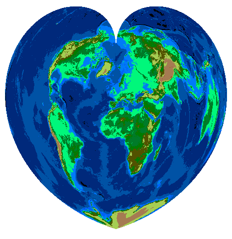
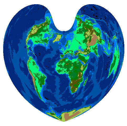
 Originally posted for Valentine's Day. A choice of cordiform (heart
shaped) map projections. On the left is the Werner and to the right is
the Bonne. Both are pseudoconic, equal area projections. Click on the maps
for full sized versions. I liked the Laskowski Minimum Error projection
display by Paul
B. Anderson so much that I decided to impose on him for this pair!
Originally posted for Valentine's Day. A choice of cordiform (heart
shaped) map projections. On the left is the Werner and to the right is
the Bonne. Both are pseudoconic, equal area projections. Click on the maps
for full sized versions. I liked the Laskowski Minimum Error projection
display by Paul
B. Anderson so much that I decided to impose on him for this pair!
 Can
you identify the map projection? From the expert, John P. Snyder, "I
think it is an equatorial stereographic projection, which appears to suit
the cartography of the period -- note the eastern coastline of Asia --
but more technically is indicated by the fact that the parallels, most
notably the 80th, intersect the outer meridians, and other meridians, at
right angles. On the globular projection, not used much for such published
maps until the 19th century, the parallels are usually not at right angles,
most visibly where the 80th parallel strikes the 90th meridians from center."
Can
you identify the map projection? From the expert, John P. Snyder, "I
think it is an equatorial stereographic projection, which appears to suit
the cartography of the period -- note the eastern coastline of Asia --
but more technically is indicated by the fact that the parallels, most
notably the 80th, intersect the outer meridians, and other meridians, at
right angles. On the globular projection, not used much for such published
maps until the 19th century, the parallels are usually not at right angles,
most visibly where the 80th parallel strikes the 90th meridians from center."
 Trivia.
Can you identify this projection and the dataset used? Information and
graphic are kindly provided by Paul
B. Anderson. Solution
Return to
The Map Projection Home Page
Last updated 9/26/97 by Karen Mulcahy - mulcahy@geog.ecu.edu