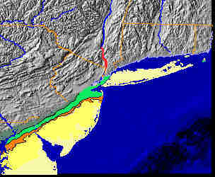
The Navesink River separates Sandy Hook from the Atlantic
Highlands. The Atlantic Highlands are the highest headlands
along the Atlantic Coast south of Maine. Resistant Tertiary-aged
ironstone conglomerate forms a caprock along the crest of the
Atlantic Highlands, overlying gently seaward-dipping Cretaceous
marine mudrocks. When sea level was lower during the Ice Ages
the Atlantic Highlands was a high valley wall on the south side
of the Hudson River.
Click here: Stratigraphy of the Coastal Plain provides a summary of sedimentary formations in the NY Bight region.
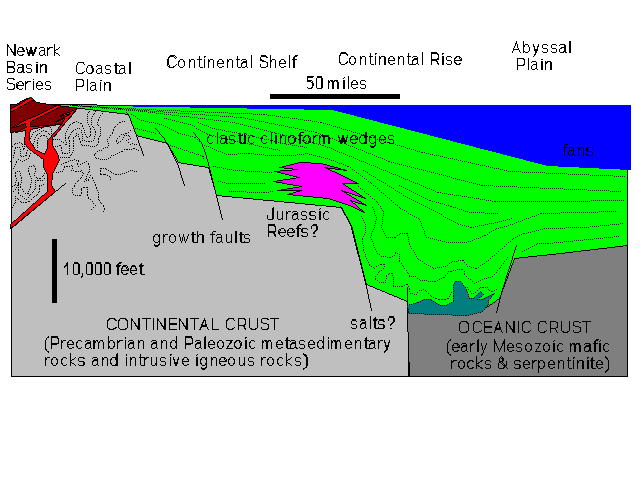
The genesis of the Atlantic Ocean occurred as marine waters haltingly flooded northward into the widening rift system during Jurassic time. As the Atlantic Ocean widened, the eastern margin of the North American continent gradually stabilized, ending sedimentation in the "aborted rift" basins (such as the Newark Basin). (The technical term for the East Coast is "passive margin" - meaning that the margin is on the tectonically inactive trailing end of a moving continent. This is opposed to an "active margin" which would be an apt description for the East Coast during most of Paleozoic time. The West Coast is currently an "active margin.") Continuous erosion throughout the Appalachian region supplied sediments into the young Atlantic Ocean. In the early stages of ocean basin development, before large river drainage basins had developed, large quantities of salt accumulated in the narrow, restricted Atlantic Ocean basin. As the ocean widened and more normal marine conditions persisted great organic reefs (limestone) began to accumulate along the shelf edge. Reef growth persisted through Early Cretaceous time. During Late Cretaceous time (around 100 million years ago) expanding river systems draining the aging Appalachian region began providing increasing amounts of clastic sediments to the Atlantic Coastal Plain and to the shelf and deep-water basin regions offshore.
High standing seas worldwide persisted through Late Cretaceous
time (which
is one part of the argument that the "greenhouse effect" kept the
world
ice-free during late Cretaceous time). Sea level fluctuated
causing
transgressions and regression throughout Late Cretaceous time.
Probably,
cooling at the end of the Cretaceous allowed sea level to fall,
but warm
conditions returned in Paleocene, Eocene, and again in Miocene
time
(resulting in high standing seas during these ages). The ice
ages began in
the end of the Tertiary, possibly as early as late Miocene time.
The
glacial periods have been linked to Milankovitch Cycles (relating
to the combined effects of changing patterns in the Earth's
revolution,
rotation, and tilt). As many as sixteen major glaciation periods
are now
recognized in the sediment profiles around the globe.
The Atlantic Coastal Plain. (Image presented here with permission from the American Geological Institute, Joint Educational Initiative Group.)
Changes in sea level on the order of a couple hundred meters have occurred dozens of times during the last 100 million years. The cause of these sea level fluctuations during the past 40-45 million years (Middle Tertiary to recent) has been inferred. The cyclic formation of great ice sheets in both north and south latitude regions of the globe can account for these changes. Before mid-Tertiary time the cause of cyclic sea level changes is poorly understood. For instance, current understanding of the global climate during Late Cretaceous time is that Earth was too warm to support glaciers (as suggested by the presence of "warm climate" fossils in northern latitude regions). Among other possible mechanisms for changes in sea level are massive volcanism, rapid mountain-building episodes, and asteroid impacts.
Whatever the cause for cyclic changes in sea level the result is that these changes play a significant role in the occurrence (and distribution) of sedimentary material on the Coastal Plain. Erosion and tectonic submergence prior to Late Cretaceous time had reduced the topography of the Atlantic Coastal Plain region to a peneplain at sea level. High-standing seas during Late Cretaceous time (around 300 feet higher than present) allowed coastal erosion to progress westward to the location of the "fall line." The fall line is a topographic boundary between the western margin of the Coastal Plain and the eastern edge of the Appalachian Piedmont region. The physical appearance of this boundary is marked by the change from the almost flat terrain of the Coastal Plain to the rolling hills and high ridges of the Piedmont and the Appalachian highlands to the west. On a United States map the fall line can be easily traced by drawing a line connecting inland cities that grew at points along rivers where ships could no longer navigate upstream because of the presence of falls or rapids.
The fossils preserved in the sediments of the Coastal Plain record the advancement of modern species, as well as the dramatic extinction of many others. The Cretaceous/Tertiary boundary is preserved throughout the New Jersey region. The famous boundary marking severe devastation of marine fauna, and the total extinction of the dinosaurs is represented as an unconformity - a missing interval of time between layers of glauconitic marl above and below. Unfortunately, evidence of an asteroid impact as the cause for the extinction event at the end of the Cretaceous is not evident along the boundary in New Jersey. Although perhaps not as extreme, other significant extinction events are represented in the younger formation boundary layers of on the Coastal Plain. Whether these extinction events are a record of asteroid impacts or merely missing intervals of time in the sedimentary record will continue to be the focus of future research. A great impact structure was recently discovered in the vicinity of the lower Chesapeake Bay (Poag, et al., 1992). Another large crater is possibly suggested by seismic reflection data approximately 60 miles offshore from Atlantic City. These craters are the probable source of tectites (impact ejecta) found in sediments of Late Eocene age (~35 million years ago) and younger sediments throughout the Coastal Plain region.
The Late Cretaceous represents a period of the highest sea levels when global temperatures may have been the warmest known in the last billion years of Earth's history. Sea level continued to oscillate through Tertiary time until about mid-Miocene time (~15 million years ago) when the last great high-stand in sea level occurred. The evidence for this last high-stand is represented by the extensive marine sand and gravel deposits that cover much of southern New Jersey. These highly porous sands are the subsoil of the vast Pine Barrens region of New Jersey. Ancient beach ridges, barrier islands, and offshore sand and gravel deposits add subtle relief to the pine-covered landscape. For instance, Apple Pie Hill, a gravel-capped hill in the middle of the Pine Barrens consists of gravels of latest Miocene to Piocene age. This marine gravel sits approximately 120 feet above sea level. This gravel unit also caps many of the highest hills throughout the Atlantic Highlands region. The gravel of the Beacon Hill have been reworked into stream flood plain deposits, and are abundant in terrace gravels along stream valleys in the region. After mid-Miocene time sea level dropped significantly and global climates cooled, resulting in the cyclic growth of mid-latitude continental glaciers. Sea level fluctuated wildly during Pleistocene time (this is discussed in the next section).
Would you like to see what "old world" habitats may have looked
like before
humans overran the region? Take a hike at Cheesquake
State Park in New Jersey! It is a biotanical/wetlands
preserve only a
few miles south of the Outerbridge Crossing.
 NEXT
PAGE...
NEXT
PAGE...
Return to
the
New York Bight Home Page
Phil Stoffer and Paula
Messina
CUNY, Earth & Environmental Science, Ph.D. Program
Hunter College, Department of Geography
Brooklyn College, Department of Geology
In cooperation with
Gateway National Recreational Area
U.S. National Park Service
Copyright May, 1996
(All rights reserved; use as an education resource
encouraged.)>