CHAPTER 9 - HYDROLOGIC CYCLE
The "Hydrologic Cycle" refers to all processes involving the
movement and accumulation of water (and water vapor and ice)
through the atmosphere, on the Earth's surface, and beneath the
surface.
The "Water budget" - the total amount of water on earth is about
1.36 Billion cubic kilometers; covers ~71% of earth's surface.
- 97.2% oceans
- 2.15% ice
- .65% freshwater (including groundwater)
HYDROLOGIC CYCLE
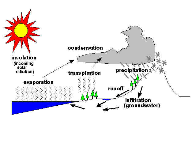
EVAPORATION - molecular exchange of a liquid and a gas (different
than boiling); water evaporates off of wet surface.
TRANSPIRATION - moisture given off by plants (by evaporation).
PRECIPITATION - condensation and gravitational fall in the form
of rain, ice, and snow.
INFILTRATION - water soaks into the ground.
RUNOFF - unable to soak in and flows on surface (cause erosion).
STREAMS
Any water flowing on the surface is considered a "stream"
(including rivers, streams, ditch, gully, brooks, creeks,
arroyos, rios, or whatever term is applied). Streams are fed by
runoff and by spring venting groundwater to the surface. Rivers
are fed mostly by groundwater flow, "floods" occurring only
during periods of precipitation or melting of ice.
- Streams fed by groundwater discharge are CLEAR.
- Streams fed by runoff from storms are typically MUDDY.
INTERMITTENT STREAM: any stream that flows when after a rain or
during a rainy season. Part or most of the year the stream
channel is dry.
Thc capacity of a stream to ERODE the landscape based on three
factors:
- GRADIENT - steeper slope, faster moving water, more erosion.
- CHANNEL SHAPE, SIZE, ROUGHNESS - restrictions cause
turbulence and affect speed: (straight, deep and wide, fast
flowing surface)
- DISCHARGE: the amount of water flowing in a stream (measured
in cubic meters per second past any point along a stream)
Discharge = channel width (m) x channel depth (m) x velocity
(m/sec)
- Mississippi River averages 17,300 cubic meters/second
(includes floods and droughts)
- Amazon = 12 times the discharge of the Mississippi.
LONGITUDINAL PROFILE OF A STREAM
These terms are used to describe characteristics of a stream
drainage system.
- DRAINAGE BASIN - area drained by a stream (river)
- HEADWATERS - upper reaches of a stream drainage, usually
steeper gradient region.
- FLOOD PLAIN - low gradient area down stream.
- MOUTH - where a stream (river) discharges into an ocean or
lake.
- MAIN CHANNEL and TRIBUTARIES: The main channel is the largest
discharge portion of a drainage system. Tributaries are smaller
streams that feed into the main channel: e.g. The Ohio, Missouri,
Arkansas, Tennesee, and Red rivers are all tributaries of the
Mississippi River.
CHARACTERISTICS OF STREAM SEDIMENT TRANSPORT
A "GRADED STREAM" has the correct gradient, channel
characteristics, and discharge to maintain transport of eroded
materials.
- SEDIMENT INPUT = SEDIMENT OUTPUT
- INCREASE DISCHARGE CAUSES EROSION
- DECREASED DISCHARGE CAUSES DEPOSITION
BASE LEVEL - lowest elevation to which a stream can erode.
- SEA LEVEL - the ultimate base level of a stream.
- Lakes - represent a "temporary" base level along a stream.
- RESISTANT ROCK LEDGES can form temporary or "local base
levels" - resulting in "waterfalls."
WORK OF STREAMS
Erosive forces of moving water scour the stream channel.
POTHOLES - scoured pits carved by pebbles swirling in eddies on
the stream bottom.
TRANSPORT of sediments in streams occurs three ways:
1. DISSOLVED LOAD - IONS in SOLLUTION (measured in "parts per
million" (PPM).
sea water has about 35,000 ppm dissolve solids
2. SUSPENDED LOAD - clay, silt, and fine sand are "carried"
by turbulent, moving water when the current too strong to allow
materials to settle out; in some cases there may be more sediment
than the water carrying it! (A famous quote about the Missouri
River is that the flooded river is "Too thick to drink; too thin
to plow.")
3) BED LOAD - sand, pebbles, cobbles, boulders too large to
be carried is suspension. Larger particles move along the bottom
of the stream by SALTATION - rolling, bouncing, and sliding.
EFFECT OF URBANIZATION
In the process of developing an urban landscape, certain
practices regarding the control of stream drainage have resulted
in catastrophe. Future generations of humans need to understand
the concepts of "resource management." The problems of
urbanization include:
- Straightened channels with pavement prevent groundwater
infiltration.
- parking lots, subdivision streets with sewers channel
rainfall.
- This results in faster discharge after storms, shorter LAG
TIME time between precipitation and flood discharge (resulting in
a greater peak discharge).
- rainfall, lag time, streamflow (discharge vs. time) are
charted below:
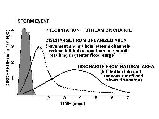
Urbanization increased risk of flood damage!
EFFECT OF BUILDING A DAM
The construction of a dam causes all kinds of disruption to the
natural stream drainage processes. Dam RESEVOIRS accomodate
flood waters by distributing flood discharge over a large surface
area. This spreads flood discharge over a longer period of time,
lowering the peak of flood stage downstream. The problems with
dams include:
STREAM SEDIMENTATION CHARACTERISTICS
A streams ability to carry sediment depends on two criteria:
- 1) COMPETENCE - measure of the maximum grain size of
particles a stream is capable of moving.
- 2) CAPACITY - the maximum load a stream can carry (which is
directly related to stream DISCHARGE).
Concepts related DEPOSITION by streams:
STREAM CHANNEL MIGRATION
- Erosion occurs on the outside of a bend. (Momentum forces the
stream current against the outside edge of a bend in the stream).
- Deposition occurs on the inside of the bend (forms gravel
bars.)
This process causes one side of the stream to migrate back and
forth across a flood plain. When a stream MEANDER encounters the
side of a valley, erosion helps to widen the valley. Streams are
constantly eroding the landscape and broadening their drainage
basins through time, sometimes "capturing" other streams by
cutting through "stream divides."
DRAINAGE SYSTEMS AND PATTERNS
The progress of time allows streams to modify the landscape and
to change the region drained by streams. Geologic features in a
region, (such as faults, rock types, and structures) control, in
part, the progress of stream development. Different geologic
structures result in recognizable stream drainage patterns.
- DRAINAGE BASIN: a region drained by a stream
- DIVIDE: imaginary line dividing two drainage basins (i.e. The
western "continental divide" separates the drainages of the
Mississippi and the rivers that drain into the Pacific Ocean.)
- DENDRITIC DRAINAGE PATTERN (tree-like) - a region underlain
by sediments, flat-lying or unconsolidated, allow an unhindered,
branching stream pattern to evolve.
- RADIAL DRAINAGE PATTERN - circular and radial drainages form
around a mountain or crater.
- RECTANGULAR DRAINAGE PATTERN - streams follow "zones of
weakness" in faulted, fractured hard-rock terrane.
- TRELLIS DRAINAGE PATTERN - folded mountain ridges of
sedimentary rocks result in parallel streams between ridges.
STAGES OF STREAM VALLEY DEVELOPMENT
As streams progress in age they modify the landscape:
- YOUTHFUL STAGE - the landscape displays "youthful
characteristics" including: V-SHAPED VALLEYS, waterfalls, rapids,
and areas with poor drainage,including swamps, bogs, and lakes.
(Youthful landscapes form during periods of glaciation, faulting
associated with the uplift formation of mountain ranges, or a
result of massive volcanic eruptions)
- MATURE STAGE - flood plains are small,stream channels are
generally straight; no natural lakes remain. Stream have no falls
and few rapids remaining.
- OLD AGE STATE - streams have wide meander belt, slack-water
swamps are common, low hills boarer broad flood plains, yazoo
tributaries.
- REJUVENATED STAGE - rapid changes in stream discharge (caused
by climate change) or sudden uplift of the land results in a
"sudden drop of stream base-level. This results in the formation
of ENTRENCHED MEANDERS and the formation of STEAM TERRACES.
- PENEPLAIN - "a completely eroded landscape" or "very old age
landscape" - such as the Canadian Shield; streams no longer have
the capacity to erode and transport sediments.
Return to the Class Web Page.