Universal Transverse Mercator system
Divide the
world into sixty vertical strips, each spanning six degrees of longitude. Apply
a custom Transverse Mercator projection to each strip and use false eastings
and northings to make all projected coordinates positive. That's the Universal
Transverse Mercator coordinate system—a comprehensive system for identifying
locations and making measurements over most of the earth's surface.
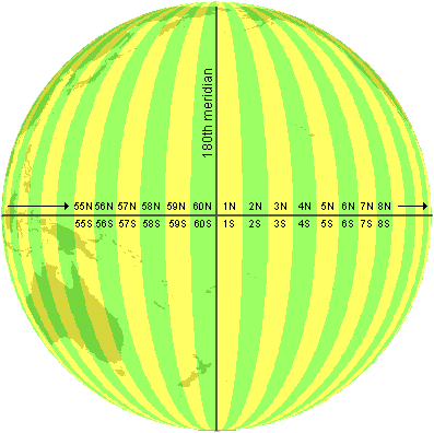
The strips,
called zones, are numbered one through sixty, starting from the 180th meridian
and moving west to east. (Zone 1 covers 180º to 174ºW, Zone 2 covers 174ºW to
168ºW and so on.) Each zone is further subdivided to indicate whether it is
north or south of the equator.
The world divided into
UTM zones.
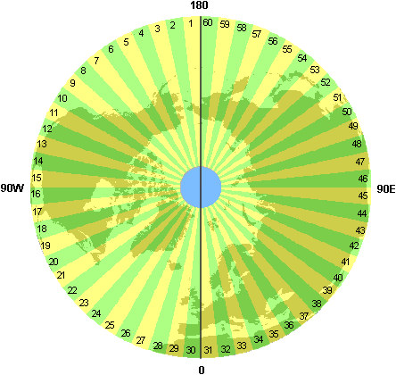
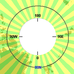
The zones of the northern
hemisphere as seen from the north pole.
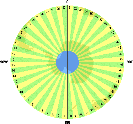
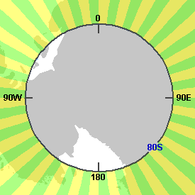
The zones of the southern
hemisphere as seen from the south pole.
In the
graphics above, the blue circles show the areas not covered by the UTM system.
The zones do not extend beyond 84°N or 80°S. (These areas are covered by the
Universal Polar Stereographic coordinate system, which complements the UTM
system.)
About
the projection
Each zone uses a custom Transverse Mercator projection with its own central
meridian. (The central meridian for Zone 1 is 177ºW, the central meridian for
Zone 2 is 171ºW, and so on.) Ordinarily, in a Transverse Mercator projection,
the central meridian is a line of true scale. In the UTM system, however, the
projection is secant, so two lines of true scale are created—one on each side
of the central meridian. As you learned in the previous module, this is a
distortion-balancing technique that compresses scale between the secant lines.
The central meridian in each UTM zone has a scale factor of 0.9996, which means
that measurements along it fall short of true scale by 4 units in 10,000 (or 1
unit in 2,500). This is the maximum scale error anywhere within the zone and is
the accuracy standard that the system was designed to meet.
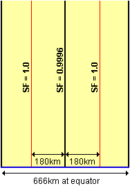
The central meridian
and lines of true scale in a UTM zone. Scale is less than 1.0 between the red
lines and greater than 1.0 outside them. Maximum scale distortion within the
zone is 1/25th of one percent.
About
the map units
Any point within a zone hemisphere can be identified by an x,y coordinate pair
that tells you how many meters east and north the point lies from the
coordinate system origin. For example, Bekins Hall (a dormitory at the
UTM Zone
11N, 484,617 meters east, 3,769,192 meters north
Where is
the coordinate system origin? The natural origin of a UTM zone is the
intersection of its central meridian with the equator, but this origin would
assign negative coordinates to some locations. To avoid this, false easting and
northing values are applied.
|
|
False easting |
False northing |
|
North zones |
500,000 m |
none |
|
South zones |
500,000 m |
10,000,000 m |
![]() More about UTM false
easting and false northing
More about UTM false
easting and false northing
False easting is needed to avoid negative x-coordinates west
of each zone's central meridian. False northing is needed to avoid negative
y-coordinates for all locations in southern hemisphere zones. (The value of ten
million meters guarantees that every point above the south pole has a positive
y-value.) Northern hemisphere zones do not use false northing because their
y-coordinates are naturally positive.
Data
that crosses zones
UTM is a precise point referencing system that allows accurate spatial analysis
within a zone. Data that crosses zones, however, is subject to rapidly
increasing distortion. Suppose you are working with data that spans zones 11N,
12N, and 13N. Since you have to project all the data using the parameters of a
single zone—say, 12N—data in the other zones will be distorted well beyond the
1 in 2,500 accuracy standard. As far as possible, you should use UTM for data
that lies within a single zone.
Universal Polar Stereographic system
The UTM
system leaves round holes at the top and bottom of the world. These are filled
in by the two zones of the Universal Polar Stereographic (
The
False
easting and false northing are applied to both zones.
|
|
False easting |
False northing |
|
|
2,000,000 m |
2,000,000 m |
|
|
2,000,000 m |
2,000,000 m |