Mercator
Without a
doubt, the most famous map projection is the Mercator
projection. In fact, the Mercator projection was the
first projection regularly identified in atlases. It is a cylindrical map
projection that is a product of its time.
During the
sixteenth century, new geographic information was pouring in from around the
world, trade routes were being established, and sailors, explorers, and
merchants needed accurate maps. After all, there's no profit or glory to be
gained from getting lost or crashing your ship on a shoal.
Knowing
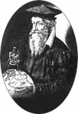
this, Gerardus Mercator
invented a new projection based on the cylinder. Mercator
invented his map projection primarily for navigation. If you draw a straight
line between two points on a map created using the Mercator
projection, that line represents the direction you
need to sail to travel between the two points. This type of route is called a rhumb line or loxodrome.
It is not the shortest route, but if you keep the direction of your ship
constant with respect to north then you will stay on course and arrive at your
destination.
Note: The methodology behind the map was probably in use before Gerardus Mercator's time, but it was so obscure that it is believed to have been independently reinvented by Mercator in 1569.
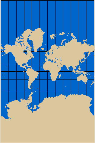
Because the Mercator map projection is cylindrical, and a cylinder is open-ended, the projection in theory goes on forever. This example has been "trimmed" before it reached 90 degrees north and south.
Because the
Mercator map projection was the most commonly misused
map projection during the nineteenth and twentieth centuries, many
misconceptions have been propagated about the basic geography of the world. For
example,
More about Gerardus Mercator
There are
actually two cartographers named Mercator. The most
prominent is Gerardus Mercator
and the other is his son, Rumold, a prominent
mapmaker in his own right.
Among
cartographers and geographers, the name Gerardus Mercator is not simply well-known, but is uttered with
reverence. As far as we know, he was the first person to apply the term atlas
to a collection of maps in book form. (The book was actually published
after Gerardus's death by his son.) It has also been
said that Mercator saw a new form of lettering in
Gerardus Mercator.
Mercator's
main claim to fame can be ascribed to two cartographic applications. He was the
first cartographer to use latitude and longitude as an aid on sailors' maps. By
applying a grid of intersecting lines (invented centuries earlier by the
Greeks) to navigational maps, he paved the way for modern nautical charts.
His second contribution was a map that still bears his name—the Mercator projection, published in 1569. Mercator called his map A New and Enlarged Description of the Earth with Corrections for Use in Navigation. No wonder future cartographers and laymen simply called it the Mercator projection. This map revolutionized navigation because any line drawn between two points on a map is a sailor's compass setting that only needs to be adjusted to compensate for magnetic north. Because most navigators in the sixteenth century relied on their own personal and very secret maps, acceptance of the map projection wasn't immediate.
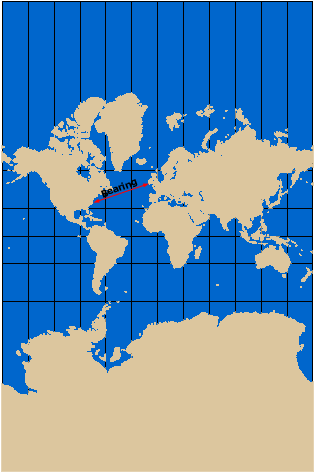
Drawing a line between two points on the map or chart shows a sailor the direction he needs to sail.
Gerard de
Kremer (Mercator's real name) was born in Dumpelunde,
He opened a
cartography workshop in 1552 where he made earth globes, celestial globes,
maps, atlases, and instruments for sailors and the wealthy. He made the first
map of
Gerardus Mercator died on
Transverse Mercator
The
Transverse Mercator map projection was invented by
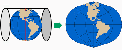
Johann Lambert and presented in 1772. Lambert rotated the Mercator
cylindrical projection 90 degrees, making the tangent line a line of longitude
instead of the equator.
Only the central meridian and the equator of the projection are straight lines. All other latitude lines and longitude lines are complex curves; that is, they cannot be represented as sections of a single circle. Unlike the Mercator projection, the Transverse Mercator projection is not used on a global scale but is applied to regions that have a general north–south orientation.
Feature distortion increases proportionally as the distance from the central meridian (the red vertical line) increases. For this reason, the Transverse Mercator map projection is applied to regions with a north-south orientation.
Although it isn't used (and can't be) to project the whole world in a single map, the Transverse Mercator is used to map the whole world in pieces—more exactly, in a series of adjacent strips. That's the idea behind the Universal Transverse Mercator coordinate system, which you'll learn about in the next session.