Locating features from north to south
Although
the graticule was developed more than two thousand
years ago, not everyone agreed where the starting point for the system should
be—that is, where was zero?
Where to
begin measuring latitude was the first problem to be tackled. The ancient
Greeks are known to have used at least two different latitude lines as their
origin. One line passed through
Latitude lines, or parallels, are actually a series of parallel circles intersecting the earth's axis at right angles and decreasing in size as they near the poles. Because only one of the parallels is a great circle, a circle that divides the earth into two equal halves, scholars reasoned using that parallel as the starting point for latitude seemed logical. This line is called the equator. The resulting southern hemisphere and northern hemisphere surfaces are theoretically equal, but because the earth isn't a perfect sphere or spheroid, the hemispheres are in fact a little different.
Great circles
A great circle is any circle that defines the point where an imaginary plane intersects the earth and divides the earth into equal halves or hemispheres. To create a great circle, you spin a sphere's diameter in any direction and trace its path. The resulting circle divides the sphere into two equal halves. Opposite meridians, when combined, create a great circle, as does the equator. All other parallels are called small circles because they fail to divide the earth into equal hemispheres.
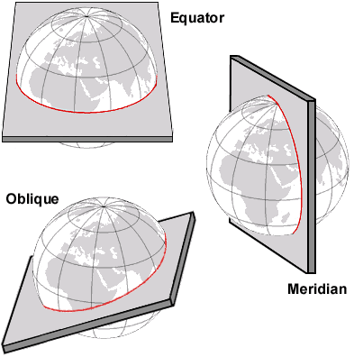
Rotating two connecting meridians or the equator in any direction creates a great circle. When the circle does not intersect the equator at a right angle, its orientation is called oblique.
An arc, or section, of a great circle represents the shortest distance between any two points on the earth. This makes great circles very useful in plotting courses for airplanes, missiles, or, in some situations, ships.
Degrees of latitude are measured from 0° to 90° north and 0° to 90° south from the equator. The north pole and the south pole are then 90° north and 90° south respectively.
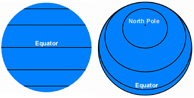
Because latitude lines are parallel, every degree of latitude is theoretically equal. Since the earth is not a perfect sphere, however, the degrees vary slightly (110.572 kilometers or 68.708 miles at the equator and 111.69 kilometers or 69.403 miles at the poles).
The invention of the compass (which points north), combined with the fact that the most influential countries were located in the northern hemisphere, meant that north was placed at the top of most maps and globes.
Locating features from east to west
Determining
the starting point, or prime meridian, for longitude is not an easy
task. Longitude lines, or meridians, converge at the poles so every meridian is
half of a circle, specifically, half of a great circle.
Since each
circle is the same size, choosing one meridian over another is completely
arbitrary. To give just a few examples, the Spanish have used a meridian
passing through
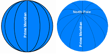
The distance for a degree of longitude varies. A degree of longitude at the equator is 111.317 kilometers or 69.171 miles, and gradually decreases toward the poles, which have a value of zero.
Degrees of
longitude are measured from 0° to 180° east and 0° to 180° west from the prime
meridian. The 180° meridian is often called the International Dateline, but the
dateline actually deviates from the meridian and is more a political or
chronological construct than a locational one.
Not every nation has adopted the Greenwich Meridian as its prime meridian. Today, several prime meridians are used by a variety of countries. When examining the coordinates for a set of features, especially from different data sources, you must be sure they are referenced from a common prime meridian.
Other prime meridians
Prime meridian longitudes listed below are based on the Greenwich Prime Meridian established at the International Meridian Conference in 1884. When evaluating maps or geospatial data from sources associated with or located in these cities or countries be sure to check the prime meridian.
|
City |
|
|
|
23° 42' 58.815" E |
|
|
7° 26' 22".5 E |
|
|
74° 04' 51".3 W |
|
|
4° 22' 04".71 E |
|
Ferro (El Hierro) |
17° 40' 00" W |
|
|
106° 48' 27".79 E |
|
|
9° 07' 54".862 W |
|
|
3° 41' 16".58 W |
|
|
2° 20' 14".025 E |
|
|
12° 27' 08".4 E |
|
|
18° 03' 29".8 E |