Creating the graticule
The idea of
using a system of intersecting lines to locate features on a map existed almost
from the inception of systematic mapmaking. As early as the third century
The first
person credited with tackling the problem of locating surface features on a
spherical earth was our friend, Eratosthenes. Eratosthenes devised a system of
north–south and east–west oriented lines encompassing the earth's surface and
intersecting each other.
In the
second century
Latitude lines
are parallel, run east and west around the earth's surface,
and measure distances north and south of the equator.
Longitude
lines run north and south around the earth's surface, intersect at the poles,
and measure distances east and west of the prime meridian.
The network of intersecting lines of latitude and longitude is called the graticule. It is imaginary on the earth, of course, but is drawn on globes and maps for reference.
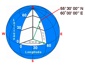
The graticule of latitude and longitude lines is an angular measurement system. All features on the earth's surface are located using measurements that are relative to the center of the earth. Latitude lines are parallel to each other while longitude lines converge at the poles.