Basics of datums
By this
point, you know that the earth can be modeled as a spheroid or (less
accurately) as a sphere. You also know that different dimensions have been used
for these models. This story goes all the way back to the ancient Greeks and
their various estimates of the earth's circumference. It takes us through
While a
spheroid is a good model, it doesn't describe the earth's shape exactly. Is
that surprising? Not really—a spheroid is a perfectly regular mathematical form
and the earth is just a big hunk of rock. Strictly speaking, we shouldn't say that
the earth's shape is an spheroid. We should say that a
spheroid is the shape that best describes the earth while still being
practical to work with.
What is the
earth's shape really like? Well, for one thing, it has mountains and valleys.
Okay, suppose we take some giant-sized sandpaper and a huge can of putty and we
sand down the bumps and fill in the cracks so that we have a perfectly smooth,
even surface. Actually, that's what surveyors and geodesists do, except that
they use math instead of sandpaper and putty. For the purpose of determining
horizontal reference points (latitude and longitude), they level their
measurements down to a surface called a geoid.
The geoid is the shape that the earth would have if
all its topography were removed—or, more accurately, if every point on the
earth's surface had the value of mean sea level.
It would be
great if the geoid were a spheroid, but it's not. The geoid
is irregular because the force of gravity isn't constant over the earth's
surface. Gravity is stronger in some areas—where dense material, like iron, is
concentrated under the earth's crust—and weaker in others. These changes are
fairly gentle, but they're significant, as you'll see in the concepts that
follow.
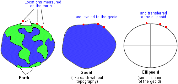
Latitude-longitude
values are measured on the earth and mathematically leveled to the geoid. This process does not affect the horizontal
positions of points. From the geoid, points are then
calculated to corresponding positions on the surface of a spheroid. This
process does affect horizontal positions.