Understanding
distortion
Converting
locations from a spherical surface to a flat surface causes distortion,
regardless of the projection surface that is used. The four spatial properties
on a map that are subject to distortion are:
· Shape
· Area
· Distance
· Direction
Each map
projection is good at preserving one or more (but not all) of the four spatial
properties.
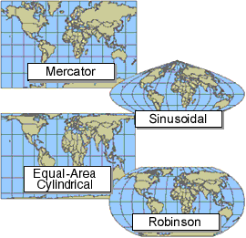
Different map projections preserve
different spatial properties and produce different-looking maps.
Shape
If a map
preserves shape, then shapes, such as outlines of countries, look the same on
the map as they do on the earth. A map that preserves shape is called
"conformal." On conformal maps, compass directions are true for a
limited distance around any given location.
Area
If a map
preserves area, then the size of a feature on the map is the same relative to
its size on the earth. On an equal area map, if you draw a shape and move it
around the map, no matter where you place it, its size will be the same.
Distance
If a map
preserves distance, then a line between one point on the map and another is the
same distance as it is on the earth (taking scale into consideration). Most
maps have one or two lines of true scale. An equidistant map preserves true
scale for all straight lines passing through a single specified location. For
example, if the map is centered on
Direction
Direction,
or azimuth, is measured in degrees of angle from north. An azimuthal projection
preserves direction for all straight lines passing through a single, specified
location. On an azimuthal map, directions from one central location to all
other points on the map will be shown correctly.
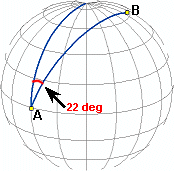
The azimuth from A to B is 22
degrees. If the azimuth value from A to B is the same on a map as it is on the
earth, then the map preserves direction from A to B.
Anyone who
uses maps should know which projections are being used and which spatial
properties are distorted and to what extent. When choosing a map projection,
think about which properties you want to preserve. If your map is large-scale
(shows a relatively small area of the earth), the effect of a map projection
will be much less than if your map is small-scale (shows a large portion of the
earth's surface).