Types
of map projections
Imagine
you could project a light source through the earth's surface onto a flat
surface. You would be able to trace the shapes of features from the earth's
spherical surface onto the flat surface.
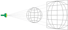
The term "map projection"
comes from the concept of projecting a light source through the earth's surface
onto a two-dimensional surface (a map).
This is the
concept behind the construction of a map projection. Although a map projection
gets its name from the idea of projecting a globe onto a flat surface, map
projections are actually created using mathematical formulas. Conceptually,
there are three types of surfaces that a map can be projected onto: a cylinder,
a cone, and a plane. Each of these surfaces can be laid flat without
distortion.
Projections
based on each surface can be used for mapping particular parts of the world.
For example, a cylinder wrapped around the earth so that it touches the equator
will produce a map that is accurate in the equatorial zone. A cone placed over
the earth so that it touches midway between the equator and the pole will
produce a map that is accurate in the mid-latitude zone. A plane that touches
the earth at a pole will produce a map that is accurate in the polar region.
Knowing the type of surface used in a map projection helps you determine if the
map projection is right for your purpose.