Understanding
datums
Now you
know that a geographic coordinate system uses a spheroid (or less accurately a
sphere) to model the earth. You also know that a spheroid doesn't describe the
earth's shape exactly—a perfectly smooth spheroid does not reflect the
undulations and other variations on the earth's surface. Because no single
spheroid can model the bumpiness all over the earth's surface, there is more
than one spheroid in use.
A
geographic coordinate system needs a way to align the spheroid being used to
the surface of the earth for the region being studied. For this purpose, a
geographic coordinate system uses a datum. A datum specifies which spheroid you
are using as your earth model and at which exact location (a single point) you
are aligning that spheroid to the earth's surface.
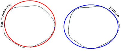
The red spheroid is aligned to the
earth to preserve accurate measurements for
A datum
defines the origin of the geographic coordinate system. The origin is the point
where the spheroid matches up perfectly with the surface of the earth and where
the latitude-longitude coordinates on the spheroid are true and accurate. All
other points in the system are referenced to the origin. In this way, a datum
determines how your geographic coordinate system assigns latitude-longitude
values to feature locations.
Just as
there are different spheroids for different parts of the world, there are
different datums to help align the spheroid to the
surface of the earth in different regions.
![]() Does
changing datums affect your data?
Does
changing datums affect your data?
If you change the datum of the geographic coordinate
system, you should know that the coordinate values of your data will also
change. For example, consider a location in
–117° 12' 57.75961" (longitude)
34° 01' 43.77884" (latitude)
Now consider the same point on the North American Datum of
1927 (NAD 1927 or NAD27).
–117° 12' 54.61539" (longitude)
34° 01' 43.72995" (latitude)
The longitude value differs by about three seconds, while
the latitude value differs by about 0.05 seconds.
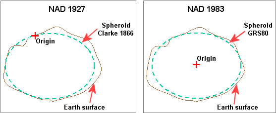
In both the NAD 1927 and the NAD 1983 datums,
the spheroid matches the earth closely in one part of the world (
The most recently developed and widely used datum for locational measurement worldwide is the World Geodetic
System of 1984 (WGS 1984). This datum is identical to NAD 1983 for most
applications. The coordinates for the same location (
–117° 12' 57.75961" (longitude)
34° 01' 43.778837" (latitude)