Getting
Started with ArcGIS
Why do
people use a geographic information system (
ArcGIS® is
the name of the family of ESRI programs. Because no two organizations are
alike, ArcGIS is designed to meet the diverse needs of organizations, small and
large. While the depth of functionality in ArcGIS is tremendous, as you'll see,
it takes a friendly approach to
This lab
provides an overview of basic
Learning objectives
A student
who completes this module will be able to:
- explore a
- preview geographic data and metadata
- add data to a map
- describe the structure of a
- explain how a
- change the way features are drawn on a map
- access feature information in different ways
Exploring
a
What's the
difference between a
You can
zoom in and out to see different areas with more or less detail, you can decide
what features you want to see and how they are symbolized, and, most
importantly, you can access a database of information about all the features
shown on the map.
In this
topic, you'll learn some of the concepts on which
Plan a
trip to
Congratulations! You've
just won a roundtrip ticket for two from
Estimated time to complete: a comfortable 40 minutes
Step 1 Start ArcMap and open a map document
Start ArcMap™ by
double-clicking your ArcMap desktop shortcut icon or by clicking your Start
menu, then clicking Programs -> ArcGIS -> ArcMap.
If you see a dialog,
choose the option to start using ArcMap with an existing map and double-click
"Browse for maps."
If you don't see the
dialog, click the Open button ![]() .
.
Navigate to your C:\Temp\Lab05
folder.
Note: If you saved the module data to a different folder than
C:\Temp, navigate to that folder.
Double-click tourism.mxd to open the map document.
Step 1: Start ArcMap and open a map
document
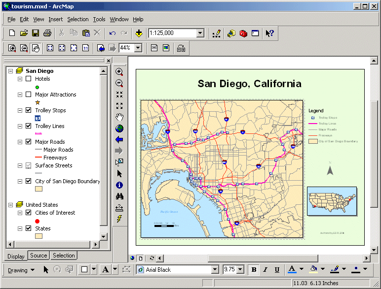
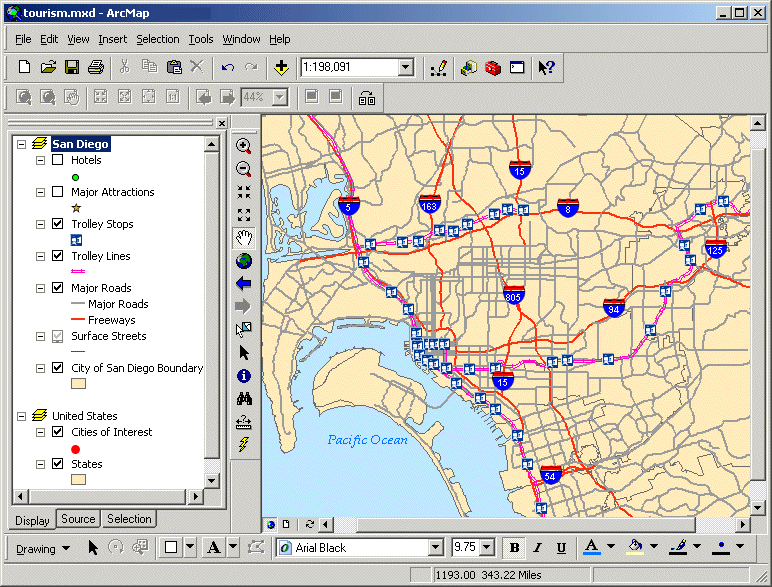
When the map opens, you
see a page layout with the title "
To the left of the map
display area, you see a list of the geographic data layers that are represented
in each of the maps. A checkmark next to a layer name means it's currently
visible on the map.
The list of layers is
called the Table of Contents. The legend on the right side of the
![]() Does your ArcMap window look different?
Does your ArcMap window look different?
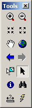
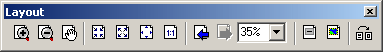
If this is the first time you've opened ArcMap, the Tools
toolbar and the Layout toolbar may be floating on your desktop. When you work
in ArcMap, you will use the tools on these toolbars often.
If you like, you can dock the toolbars to your ArcMap
window by dragging them over to the desired location. The View Result graphics
provided in this course will all show the Tools toolbar docked in between the
Table of Contents and the map display area, and the Layout toolbar docked above
the Table of Contents.
If you don't see the Tools toolbar or the Layout toolbar, right-click in the gray area next to the Help menu and check each one.
Step 2 Explore the
In the Table of Contents,
you see two ![]() icons with the names
icons with the names
In the Table of Contents,
right-click
Now the
The active data frame is
the one you are working with.
Uncheck the box next to
the States layer.
The states have
disappeared from the map. In ArcMap, you turn layers on and off by checking and
unchecking them in the Table of Contents.
Turn the States layer back
on.
Click the minus sign in
front of the
![]()
Step 2: Explore the
Now you'll turn your
attention to the
Step 3 Zoom in to
In the Table of Contents,
right-click
To see more details of the
On the Tools toolbar,
click the Zoom In tool ![]() .
.
Click in the center of the
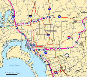
When you
zoom in, the map's scale changes.
The scale is shown in a box above the map display area.
![]()
Step 3: Zoom in to
The number in your scale box
may be different than the one shown in the View Result graphic. It depends on
how large your map display area is and how large a box you drew when you zoomed
in.
The scale is the ratio
between the size of features on the map and the size of those same features on
the earth. If the scale is 1:57,283, that means that one unit on the map is
equal to 57,283 units in the real world—or, that features in the real world are
57,283 times larger than they are on the map.
With the Zoom In tool
still active, click the center of the map.
Notice that the scale
number decreased. You'll learn more about scale later in this topic, but so
far, you've learned that you can change the scale in a
You can also change the
scale by typing directly into the scale box.
Click in the scale box and
delete the current number. Type 50000 (50 thousand) and press Enter.
The map display changes.
Now you can see more streets on the map.
The Surface Streets layer
is set to display only when the number in the scale box is 50,000 or less.
Because the surface streets are now visible in the map, their symbol is no
longer grayed out in the Table of Contents and the layer also displays in the map
legend.
Click the Pan tool ![]() .
Click in the center of the map and drag to the right.
.
Click in the center of the map and drag to the right.
Did you notice that the
scale did not change? Panning a map is a way to see different areas of the map
at the same scale.
To get the
From the View menu, choose
Bookmarks, then click
Step 4 Switch to data view and label hotels
In ArcMap, there are two
views for working with your data: layout view and data view. So far, you have
been exploring the map in layout view. In order to explore the data in more
detail, you will switch to data view.
Click the Data View button
![]() on the bottom left of your map display area.
on the bottom left of your map display area.
Step 4a: Switch to data view and
label hotels
Note the following visible
differences between layout view and data view:
- The locator map of the
- In data view, you can view only one map at a time (the active
data frame).
In the Table of Contents,
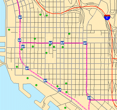
check the box next to Hotels to see the hotels display on the map.
Click the Zoom In tool and
zoom in on the cluster of hotels along the coast, the area you're interested in
staying.
Step 4b: Switch to data view and
label hotels
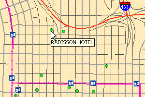
Click the Select Elements tool ![]() .
Pause your mouse pointer over the hotel symbols just
south of the Interstate 5 Freeway.
.
Pause your mouse pointer over the hotel symbols just
south of the Interstate 5 Freeway.
Step 4c: Switch to data view and
label hotels
The hotel name displays as
a map tip when you hover over its symbol.
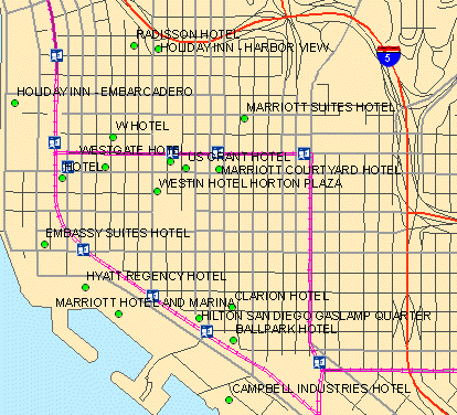
To see the names of all
the hotels at once, you will turn on their labels.
Right-click Hotels and
choose Label Features.
Step 4d: Switch to data view and
label hotels
Step 5 Find a hotel and get information about it
You participate in the
Marriott Rewards program and are happy to see a couple of Marriott hotels on
the map. Hopefully, you can find one that's located near the trolley line and
the ocean. It would be a huge cost savings if you could walk or take the
trolley to sightsee instead of renting a car.
With a
Click the Find tool ![]() .
.
The Find dialog opens.
In the Find field, type Marriott.
Click the dropdown arrow next to "In" and choose Hotels.
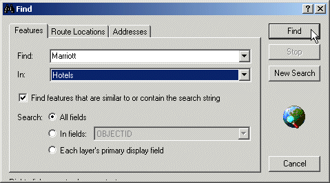
Step 5a: Find a hotel and get information
about it
Click Find.
Move the Find dialog so
you can see both it and the map. At the bottom of the Find dialog, right-click
Marriott Suites Hotel and choose Flash Feature.
If you were watching, you
should have seen the hotel flash on the map.
If you didn't see the
hotel flash on the map, try it again.
Flash the location of the
Marriott Hotel and
![]() 1 Why would this hotel be a desirable location?
1 Why would this hotel be a desirable location?
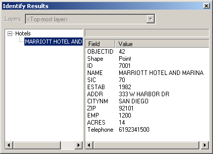
You'd like to get the
telephone number for the Marriott Hotel and
In the Find dialog,
right-click Marriott Hotel and
The Identify Results
window opens. Here you see a list of information about the Marriott Hotel and
If necessary, enlarge the
Identify Results window so you can see all the information about the hotel.
Step 5b: Find a hotel and get
information about it
Features on a
![]() 2 What is the hotel's telephone number?
2 What is the hotel's telephone number?
Now that you have the
phone number for the hotel, you can call to make reservations.
Close the Identify Results
window.
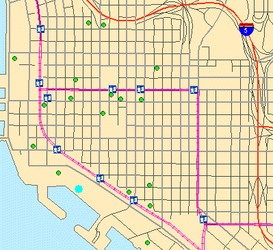
In the Find dialog,
right-click the Marriott Hotel and
Now you see a light blue
dot over the hotel symbol. You will keep this hotel symbol selected so you can
easily see where your hotel of choice is in comparison to the trolley line and
major attractions.
In the Table of Contents,
right-click Hotels and choose Label Features to remove their labels.
Step 5c: Find a hotel and get
information about it
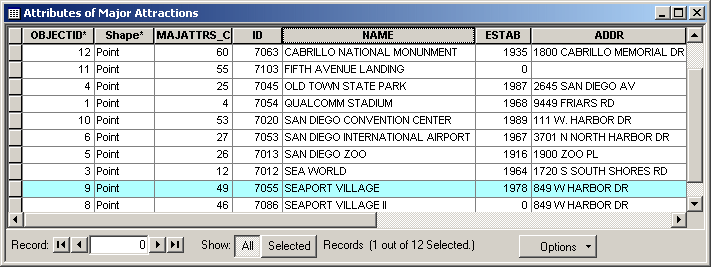
Step 6 Get information about major attractions
Next, you'll explore some
of the attractions you'd like to visit while you're in
In the Table of Contents,
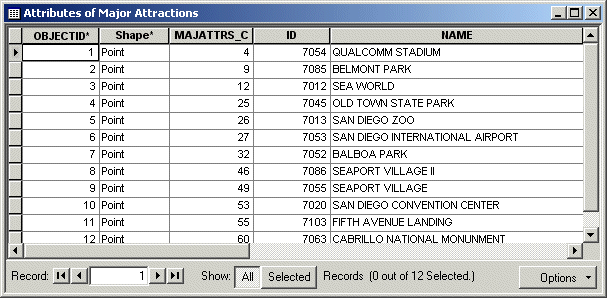
check Major Attractions. Right-click Major Attractions and choose Open
Attribute Table.
Step 6a: Get information about
major attractions
This table contains
information about each major attraction that's displayed on the map. It's
another way to view information about the features in a layer. In the previous
step, you accessed information about a feature using the Identify Results
window.
In this table, each major
attraction has its own record, or row, in the table. Each column represents a
type of information, or attribute, for each record.
Scroll to the right of the
table and examine the fields.
Right-click the NAME field
name and choose Sort Ascending.
Now all the major
attractions are sorted alphabetically. This makes it easier to find a
particular attraction.
Scroll down until you find
The
Step 6b: Get information about
major attractions
![]() 3 What is the address of
3 What is the address of
Close the table.
Notice that the symbol for
Step 6c: Get information about
major attractions
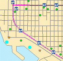
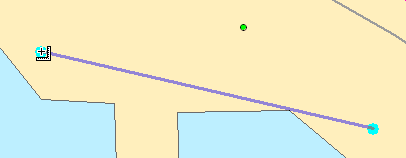
Step 7 Measure distance between features
To make it easier to
measure the distance between the hotel and
Click the Zoom In tool and
draw a box around the two selected features.
Click the Measure tool ![]() .
.
Notice that your mouse
pointer changes to a ruler when you move it over the map.
Click the symbol for the
Marriott Hotel and
Tip: If you don't remember which symbol is
the hotel, pause your mouse pointer over each symbol
to see its map tip.
Step 7a: Measure distance between
features
Double-click to measure
the distance. Look at the status bar at the bottom left of your ArcMap window.
Tip: If you don't see the ArcMap status
bar, click the View menu and check Status Bar.
The distance you measured
displays there.
![]() 4 Approximately how far is it from the
Marriott Hotel and
4 Approximately how far is it from the
Marriott Hotel and
Notice that the trolley
line is also close to the hotel.
Use the Measure tool to
measure the distance from the Marriott Hotel and ![]() to see the nearest trolley stop.
to see the nearest trolley stop.
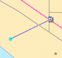
Step 7b: Measure distance between
features
![]() 5 Approximately how far is the nearest trolley
stop?
5 Approximately how far is the nearest trolley
stop?
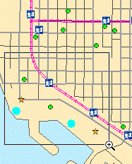
Next, you'll see if you can take the trolley to the San Diego Zoo and Qualcomm Stadium, two other attractions you want to visit.
Step 8 Find attractions and determine the best method of transportation
You're a big sports fan.
You've already done some research and found out there's a game you want to see
while you're in
From the Selection menu,
choose Clear Selected Features.
From the View menu, choose
Bookmarks, then click
In the Table of Contents,
turn off Major Roads. Right-click Major Attractions and choose Label Features.
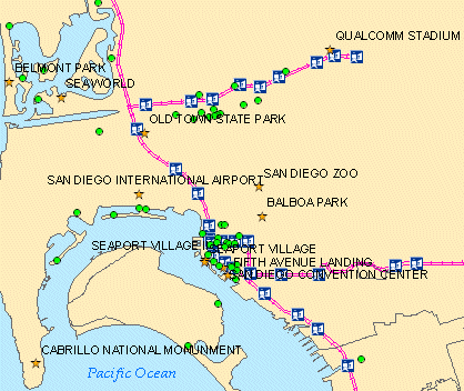
Step 8: Find attractions and
determine the best method of transportation
Look for Qualcomm Stadium
on the map.
It looks like there's a
trolley stop very close to the stadium.
Click the Identify tool ![]() .
.
The Identify Results
window opens.
In the Layers dropdown
list, choose Trolley Stops.
On the map, click the
trolley stop closest to Qualcomm Stadium.
![]() 6 What is the name of the trolley stop?
6 What is the name of the trolley stop?
Close the Identify Results
window.
Now look for the San Diego
Zoo on the map.
You've always heard how beautiful the San Diego Zoo is and would really like to visit it on your trip. In the next step, you'll get more information about the zoo.
Step 9 Use a hyperlink for the
A
Zoom in to the
Click the Hyperlink tool ![]() ,
then click the San Diego Zoo symbol (Tip: Click the blue dot over the symbol).
,
then click the San Diego Zoo symbol (Tip: Click the blue dot over the symbol).
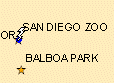
The Web site for the San
Diego Zoo opens.
If the Web site doesn't
open, try clicking the blue dot again. You need to click in the center of the
dot.
Briefly explore the Visit
section to see what type of information it contains.
Close the browser window with the San Diego Zoo Web site.
Step 10 Close ArcMap
From the File menu, choose Exit. Click No when asked if you want to save changes.
This exercise introduced
you to some of the features of a
While exploring this
So not forget to save your five answers from your Notepad file. Send them both to Jing Li and to yourself (as a backup).