Public Land Survey system
The United
States Public Land Survey System (abbreviated PLSS or USPLS) is a locational reference system, but not strictly a planar
coordinate system. It is different from the systems you have been reading about
in a few important ways.
·
It
is used to locate areas, not points.
·
It
isn't rigorous enough for spatial analysis like the calculation of distance or
direction.
·
It
is not a grid imposed on a map projection (a system invented in a room), but
lines measured on the ground by surveyors.
The PLSS
was established by Congress in 1785. Its purpose was to partition public lands
into small, clearly-defined units so that settlement of the western
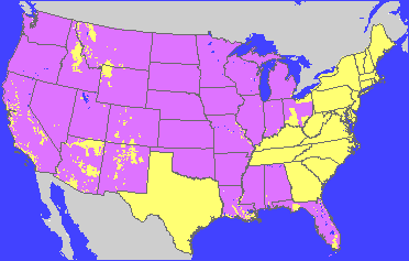
Areas covered by the
Public Land Survey system are shown in purple.
How it
works
The basic unit of the PLSS is the township, an area
six miles square. The system as a whole is a vast block of adjacent townships.
Although it is not divided neatly into zones, the PLSS is made up of several
regions, each with its own origin. Each origin is the intersection of a
meridian (called a principal meridian) and a parallel (called a baseline).
These more or less arbitrarily chosen locations define the starting point of
the survey for a given region and the numbering scheme of the townships it
includes.
The
principal meridians and baselines are shown in the following graphic. Each
separate patch of color is a different region.
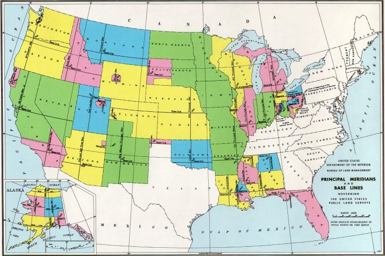
Principal
meridians and baselines of the Public Land Survey system. This map was
downloaded from the Web site of the Bureau of Land Management in
The system
divides into smaller and smaller units, always based on squares, as shown in
the following graphics.
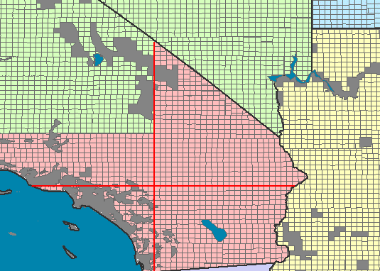
PLSS townships in
southern
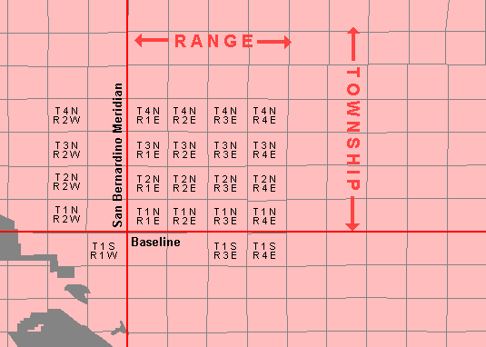
Each township, or
six-square-mile block, is identified by a Township and Range label. The labels
start at the intersection of the principal meridian and baseline. Township
values (rows) increment north and south of the baseline. Range values (columns)
increment east and west of the principal meridian. The numbering scheme
continues to the boundary of an adjacent survey.
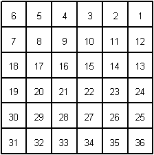
A township is divided
into 36 sections, each a square mile (640 acres). Sections are numbered by row,
beginning in the upper right corner. The numbers reverse direction with each
row.
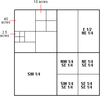
A section, in turn, is
divided into 160-acre quarters, identified by quadrant (NW, NE, SW, SE). These quarters can be further divided into halves,
quarters, and so on, with each piece identified by its geographic position. For
example, the ten-acre square labeled in the graphic is the northwest quarter of
the northeast quarter of the northwest quarter of the section.
To identify
a location in PLSS, you start at the most detailed level and work your way out.
In the graphic below, the location (indicated by blue squares) is:
SW1/4, NE 1/4, Section 28, T.4N.-R.2E., San Bernardino P.M.
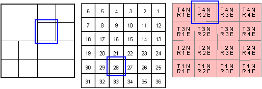
How a sample location is
identified in the PLSS.
Since the
PLSS framework is constructed from ground surveys, it has plenty of
irregularities. In the first place, you can't lay out a grid of perfect squares
over a large distance on the round earth. The PLSS makes corrections at every
fourth township line and every fourth range line, so that townships are
slightly offset from one another every 24 miles. In addition, many practical
problems occur in the course of such a huge project and many surveying errors
are made. Nonetheless, the PLSS is a very successful system and remains the
basis for most land ownership documents in the