c
The Lambert Conformal Conic projection was also developed by Johann Lambert around 1772. A conic projection that preserves shape (as its name implies), the projection wasn't appreciated for nearly a century after its invention.
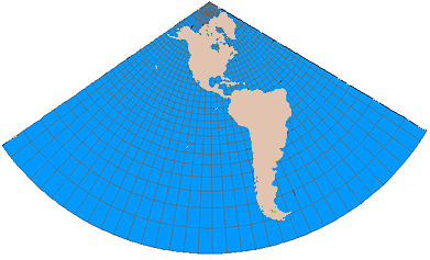
In a Lambert Conformal
Conic map projection, latitude lines are unequally spaced arcs that are
portions of concentric circles. Longitude lines are actually radii of the same
circles that define the latitude lines. Poles are represented as single points.
Notice the extreme distortion of the features farthest away from
The Lambert
Conformal Conic projection is one of the best projections for middle latitudes
with an east–west orientation. It portrays shape more accurately than area and
is common in many maps and geographic databases for
The Lambert Conformal Conic projection can use a single latitude line as its point of contact (a tangent line), or the cone can intersect the earth's surface along two lines, called secants. Along these two lines there is no distortion, but distortion does occur as the distance from the secants increases.
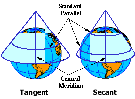
Distortion increases as you move away from the secant lines and the central meridian.
More about Johann Lambert
Johann Heinrich Lambert lived during a time when mathematics was expanding at a phenomenal rate. It was early in this period, known as the Mathematical Age of Enlightenment, that Isaac Newton lived and calculus was invented. Nearly a century later, Lambert used calculus so extensively that, without it, many of his advances in cartography probably could not have been made.
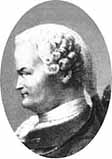
Johann Heinrich Lambert.
Lambert was
born
Many of his
projections are still in use today and most carry his name, although he never
actually named any of them. The most prominent of them are:
·
Lambert
Conformal Conic
·
Lambert
Cylindrical
·
Lambert
Conical Equal Area
·
Lambert
Azimuthal Equal Area
·
Transverse
Mercator
·
Transverse
Cylindrical Equal Area
Even this
incomplete list shows how prolific he was. To say his influence is felt today
through all the geosciences would be an understatement. The Lambert Conformal
Conic, Transverse Mercator, and Lambert Azimuthal are three of the most common map projections used
today and are applied daily in a variety of
Lambert
died on