
 Ni-Meister Research Lab
 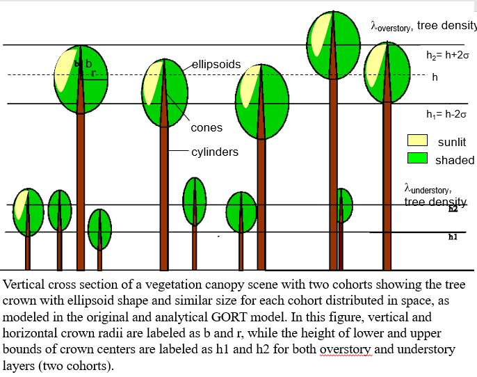 Canopy Radiative Transfer
We study light and how light interacts with three-dimensional canopy structure. We developed uique Geometric Optical Radiative Transfer (GORT) models to characterize the heterogeneous radiation environment in natural vegetation at the forest stand scale and how the three dimensional heterogenous vegetation structure affect light abortion, light transmission and light scattering. These processes are key to understand how satellites observe the Earth land surface and how vegetation structure controls the land surface biophysical processes that contributes to CO2 uptake and emission.
Merging theory from geometric optics and radiative transfer, the GORT model treats vegetation canopies as assemblages of randomly distributed tree crowns of ellipsoidal shape with different stage ages (multicohorts). The tree crowns are filled with leaves that absorb and scatter radiation passing through the crown. Principles of radiative transfer are used to describe both the multiple scattering of leaves and stems inside crowns, and the multiple scattering among crowns and the ground surface. The GORT scheme offers a sound theoretical framework to: a) link vegetation structure with lidar measurements and b) scale leaf processes to the canopy scale with regard to light scattering and production of CO2 fluxes.
 Lidar Remote Sensing
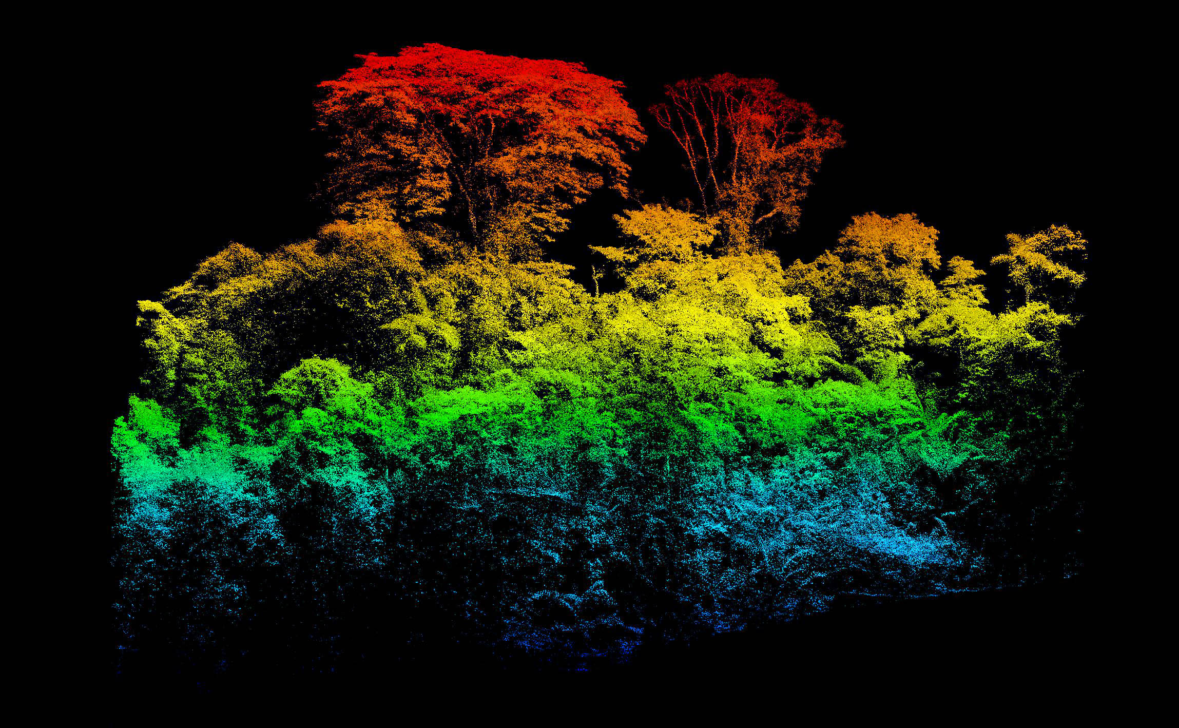
 We use lidar remote sensing to fully characterize the heterogeneity of vegetation structure. We use the GORT model to understand lidar measurements and to infer vegetation structure measurements from these measurements.
The GORT model has been used successfully in describing the BRDF characteristics of forests then extended it to include the vertical canopy gap probability, defined as the probability of light beams passing through vegetation canopy without hitting any canopy element. The canopy gap probability is the key for replicating lidar observations. Canopy gap probability of a GORT model is the bridge to link vegetation structure with GEDI measurements and to fuse dVGVMs with GEDI.
 Ent Demographic Terrestrial Biosphere Model (Ent TBM)
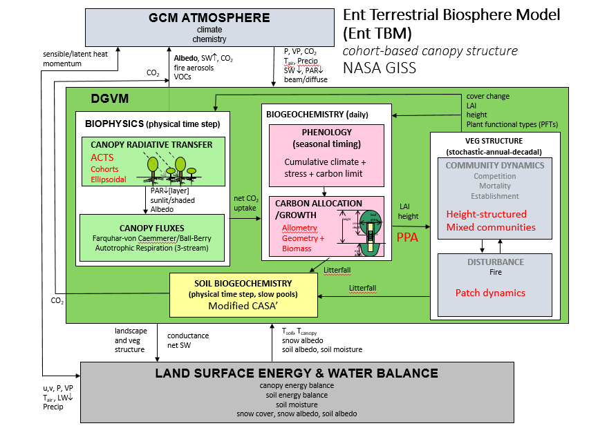
 Collaborating with NASA colleagues, we developed the Ent Terrestrial Biosphere Model (Ent TBM), a novel demographic dynamic global vegetation model (DGVM), Currently Ent has been coupled to the NASA Goddard Institute for Space Studies Earth System Model (GISS ESM) to study vegetation and climate fedback. Ent incorporates well-described structures of heterogeneous canopies through a GORT model, the Analytical Clumped Two-Stream (ACTS) model. It provides the GISS ESM’s surface fluxes of CO2 and water vapor, and is used in the GISS ESM ModelE2.1’s contribution to the sixth phase of the Coupled Model Intercomparison Project (CMIP6) Coupled Climate-Carbon Cycle MIP (C4MIP)
The ACTS model was developed for Ent to ensure a canopy radiative transfer model that could be computationally efficient, while accounting for foliage clumping and dynamically changing vegetation structure, in calculating the canopy albedo for the surface energy balance with the atmosphere, and for calculating the vertical profiles of light for simulation of leaf photosynthesis scaled to the canopy. This modeling framework is ideal to ingest vegetation structure measured by global vegetation structure measurements from GEDI mission into a DGVM to assess the role of vegetation structure on carbon fluxes and stocks.
 Snow-Vegetation Demography Interactions in the Boreal Snow-Albedo Feedback in an Earth System Model
 The northern high-latitude (>40°N) land surface winter climate has experienced intensified warming, at almost 2.5 times the global average warming in the past two decades. The decreased snow albedo feedback due to warming in return enhances the warming in the atmosphere. The strength of snow albedo feedback (SAF) can be quantified by the decrease of surface albedo due to decreased snow cover and aged snow after melting and increased temperature. However in boreal regions, forest cover shading has a strong impact on SAF. Realistically simulating the impact of forest structure on seasonal evolution of snow-covered surface albedo in boreal region has proven to be challenging for many climate models. Oversimplification of the effect of boreal forest structure in key snow process and snow albedo estimates in the current Earth System Model (ESM) causes the large spread in simulated SAF and large uncertainty for projections of climate warming over NH land areas.
We develop a physics-based framework that integrates radiative transfer of both snow and heterogeneous vegetation canopies in the boreal zone in the Ent Terrestrial Biosphere Model (Ent TBM), coupled to the NASA Goddard Institute for Space Studies Earth System Model (GISS ESM) to study the role of vegetation on snow albedo feedback. The Ent/ACTS model accounts for the clumping of foliage within tree crowns for communities of trees of different height classes and population densities (cohorts), predicting canopy albedo and light transmittance consistent with lidar remote sensing of canopy structure. To specify such heterogeneous canopy structures, versions of an Ent Global Vegetation Structure Dataset (GVSD) have been developed from ICESat/GLAS observations of canopy heights and other remotely sensed data to derive canopy demography, and newer versions are forthcoming with increasingly complex community structure and at high spatial resolution with ICESat-2 and GEDI data.
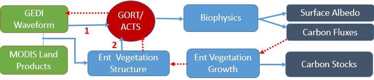
Our goal is to understand the role of accurate canopy structure on the function of land ecosystems. The GEDI mission offers unprecedented data to characterize the vertical structure of land ecosystems at temperate and tropical forests between 51.60 N & S latitude. The Geometric Optical Radiative Transfer (GORT) canopy model offers a physics-based approach to represent, statistically, the heterogeneous distribution of foliage within crowns, and light scattering and absorption within canopy, directly simulates how lidar samples a canopy. The novel demographic DGVM, the Ent Terrestrial Biosphere Model (Ent TBM), coupled to the NASA Goddard Institute for Space Studies Earth System Model (GISS ESM), incorporates well-described structures of heterogeneous canopies through a GORT model, the Analytical Clumped Two-Stream (ACTS) model to describe vegetation structure controls the land surface biophysical processes that contributes to CO2 uptake and emission.. We integrate GEDI waveform measurements into Ent to investigate a) the level of accuracy possible for deriving height-varying ecosystem structure; b) the sensitivity of land carbon stocks and fluxes and community dynamics to ecosystem structure. This self-consistent scheme will then provide vetted algorithms to enable increased use of GEDI lidar data and similar satellite data to provide global canopy structure information to dDGVMs and improve the ability of these models to simulate carbon, water, and energy fluxes and ecological dynamics of competition and vegetation change.
Working with the collaorators in NASA Jet Propulsion Laboratory, We will develop a multi-sensor, multi-platform surface topography and vegetation structure (STV) data fusion information system (STV-FIS) to characterize future STV performance. Our STV-FIS will address all four major gaps and gap-filling activities identified in the STV incubation study white paper (STVWP, p. vii). Our goal is to leverage existing models and data in active sensing of STV geophysical parameters to build a multi-sensor, multi-platform STV Data Fusion Information System (STV-FIS) to address the STV identified gaps by focusing on the following objectives: Obj-1. Develop a multi-sensor (Radar and Lidar) fusion formulation and testing platform based on a dedicated EM model of vegetation 3D structure and surface condition (topography, dry, wet, snow, etc.). Obj-2. Develop Artificial Intelligence (AI) model-data analytics for sensitivity analysis, STV parameter retrieval, change detection, and uncertainty assessment. Obj-3. Simulate a dedicated data fusion observing system for multi-sensor and multiplatform trade study, and on-board processing and smart-tasking. Obj-4. Integrate model and data fusion within a visualization system and on-line analytical toolbox for enabling simulations of STV observations, AI algorithms, and implementation future OSSEs. The proposed STV-FIS include a user-friendly platform along with visualization and algorithmic tool boxes to meet the needs of all STV disciplines for data analysis, trade studies and OSSEs. Ni-Meister team dedicates their effort to simulate lidar measurements of vegetation structure and surface topography.